Showing posts with label mt. hood. Show all posts

Sunday, October 6, 2013

To the Lighthouse

Yes, I know, Virginia Woolf already wrote that story. But in this instance I really was trying to get to a lighthouse, just without all the angst associated with the other story. One of my favorite spots in the area is Sauvie Island. It has a small lighthouse on an equally small outcropping of rock called Warrior Rock. The story goes that in the late 1700's a British Naval expedition landed on Sauvie Island and was greeted by warriors of the Multnomah tribe. There was some trading between the two groups, and the point where they met was called Warrior Rock to commemorate the occasion. The lighthouse, Oregon's smallest and one of only two Oregon lighthouses not on the Pacific Ocean, guides river traffic on the Columbia. I have had several past attempts at hiking out to the lighthouse and Friday's adventure was yet another failed attempt, but at least this time I actually caught a glimpse of it. With a little imagination, the lighthouse can be seen at the end of the line of trees on the left in the picture above. Well, with maybe more than just a little imagination.

I had decided that the first sunny Friday in October I would take a vacation day  to capture some fall colors. I was hoping it would be a little later in the month when there was more color, but when you live in such a temperamental state you take any sunny day you can get no matter when it comes along. So when this past Friday was predicted to be 70 and sunny, I put in my vacation request. When I left Portland around 9:30 in the morning it was almost clear. As I got closer and closer to Sauvie Island, it got cloudier and cloudier. I was not amused. I parked at one of the designated areas and started walking, looking for any sign of blue sky in the middle of all the gray. Finally, about noon, the skies started to clear. I sat on an old fallen tree eating carrots and humus and thoroughly enjoying the scene before me.

This particular part of the island has little traffic, especially this time of year, and each time I've been there it has the feeling of walking through a landscape painting or a picture in an old story book. This area has a trail that runs roughly parallel with the main road and then intersects it at a point where the other road turns to gravel. I was heading for this intersection and just happened to look over my shoulder to see a mountain peering at me over the canal.


Once the two roads intersect, it's a long straight walk to the trail head. There are numerous signs for Collins Beach along the way, which is a clothing optional spot. I was half tempted to jump out of the underbrush with my camera aimed at any unsuspecting sunbather just to see if I could get anyone to scurry away to take cover, but I decided I better not. After passing numerous cows and old barns, I finally found my way to the beach. I was going to take the trail out to the lighthouse and follow the coastline back but there was some trail construction going on so I decided to go out and back the same way.

 Mt. St. Helens, Mt. Adams (I just found out that the mountain I'd thought was Rainier all these years is actually Mt. Adams), and Mt. Hood were all out with their fresh layers of snow. I thought this time I would make it all the way for sure, but alas it was not to be. The beach soon became a sea of mud and the trail was almost as bad. I could feel my shoes being sucked off my feet and decided it would have to wait yet again. I'm sure the lighthouse isn't going anywhere soon and it will give me another excuse to drive back to the island next summer or spring.


Sunday, June 30, 2013

North by Norhtwest

One of the things I've come to appreciate about the Portland area is its diversity, and I don't mean the politically correct version of the word that is so popular now. By diversity I mean all the different areas you can visit in one day within about a three-mile radius (in this case, forest, city, and island). This past week has been absolutely perfect as far as weather is concerned. Summer normally doesn't come until July 5, but at least for now it's here in full force. Since there was no reason to wait for the clouds to clear or the sun to come out, I headed to northwest Portland early on to begin an urban hike. I drove across the St. John's Bridge and parked in one of the neighborhoods across from Cathedral Park. Driving across bridges takes no time at all, but walking back across is another story. The St. John's Bridge is no exception, but at least it's got a pretty view on the way.
 From up here, it was very easy to see Mt. Hood wreathed in clouds behind the Steel Bridge, as if it just couldn't quite step out of its comfy white cloak. After crossing the bridge, I found the steps that lead up to the Ridge Trail, part of the Wildwood Trail system that makes an approximately 40-mile loop through Forest Park. There were glimpses of the bridge through the trees, and it didn't take long to be almost level with the Gothic spires. The trail wound its way up for some time (much farther and twistier than Google showed, how surprising!) until it joined Leif Erikson Drive. The word "drive" is misleading because really it's a wide dirt multi-use trail, as in bikers, runners, dads with strollers, probably even unicycles at times (the bagpiping Gandolph can't always be riding in downtown, right?) so there was plenty of traffic to keep one from feeling too lonely. There are also well-placed maps at different junctions to keep hikers from getting lost, well usually. There was one intersection where the signage was particularly unhelpful and it does no good to look for moss on the north side of a tree because moss grows on all sides and surfaces.
Enough sunlight does filter in to allow certain varieties of flowers to grow. I have no idea what the flowers on the left are, but they rather remind me of inflated turbans. Columbine also makes an occasional appearance, and it's almost always in this red and yellow combination. At times the trail had rather a Shire look to it. If it wasn't for the posts on the side of the bridge, you could almost imagine elves (and yes I know, elves aren't technically in the Shire) making their way over the stream and tripping lightly up the steps, as opposed to hobbits who don't do anything lightly with those hairy feet.

 I took a wrong turn here and went up the steps because I've learned in the past that when in doubt, go up. This time the "up" trail appears to have been a shortcut to the back side of one of the businesses along Highway 30. I retraced my steps and went along the trail that paralleled the stream. It was then less than a quarter of a mile back to the highway and along the raised sidewalks that are part of what used to be the community of Linnton. From what little research I've done, Linnton used to be a thriving town. That changed when the highway was widened and the roadside businesses became level asphalt. There are still some homes dotting the landscape and businesses along the east side of the highway but apparently it never recovered its past glory. One of the things left behind was a series of staircases and raised sidewalks that allowed the townsfolk easier access to bus stops and businesses. Those are on the agenda for a future hike.

It was at least a mile or so back to the car and on the way I explored the block-wide farmers market on the east side of the St. John's Bridge. There was everything from local berries to salsa and tamales and crepes. Good thing I didn't have any cash or I might have spent it.

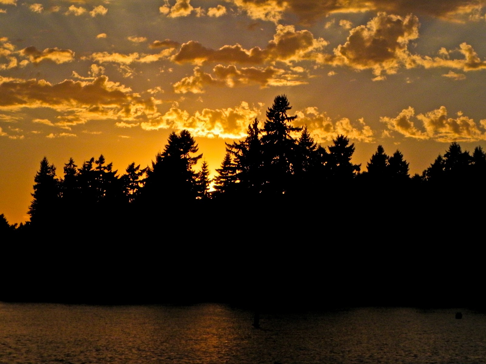
Next it was off to Sauvies Island to pick berries. This past week, a co-worker mentioned that her daughter and boyfriend had picked berries at Sauvies Island Farms and that at $2 a pound, the berries were much cheaper than those at the farmers market. I'm not sure if the cheapness factor holds up when you calculate gas, time, and effort, but it was still a fun way to spend the afternoon. The island is connected to the highway by a bridge that crosses the Willamette River. Along the river are houseboats and the area is dotted with farms. I usually leave my car at the park and ride and walk along the road to whatever the destination is. It always feels like walking in a postcard, that is if you ignore the cars that whiz by on their way to the local beach. The clouds were just beginning to clear from the mountains and the fields of flowers made a great foreground. The sprinklers were an unfortunate distraction but you can't arrange real life very easily.

 After about a three-mile walk, I was at the farm. A lady at the entrance was directing people to the proper fields and giving out cardboard flats to hold berries. The road to the berry patch had a view of Mt. St. Helens and flower patches along the way. Lavender, daisies, hydrangeas, and lilies were growing side by side waiting to be picked and turned into a bouquet. After passing corn, cabbage, kale, and other veggies, I finally found the raspberry section. The berries were the size of medium strawberries and were growing in abundance. It was no time at all before my container was filled and it was off to the blueberry patch. Again, the berries were huge and picking berries in a civilized field was quite a pleasant switch from picking thorny blackberries on the side of the road.

On the way back, I was struck again by the beauty of Mt. Hood with the flowers in front of it. Ignoring the idea that I should put my cardboard flat loaded with three plastic containers of berries down before taking the picture, I tried holding the flat and taking the picture. Let's just say, it didn't work. I was down on my knees picking up blueberries when I looked up and realized this was actually the best angle for the picture. Someone on their hands and knees picking up blueberries and then taking pictures probably looked pretty crazy to those driving by, but if I ever see those people again they won't recognize me anyway so it doesn't matter.
.

Sunday, October 21, 2012

Rain and/or Shine


 Fall and spring are the times of year when you never know what to wear. Just because the ark floated by your window does not mean that in 10 minutes the sun will not be shining. Add the appropriate temperature adjustments for both rain and shine and it's easy to see how you could walk out of the house with a wardrobe trunk that would make any Vaudeville performer proud. Yesterday's sunrise was as unpredictable as the weather. I left the house and drove to a nearby area where a house is being built. The backyard looks onto both the lake of Lake Oswego with Mt. Hood vying for attention in the background. Even more importantly, no trees obstruct the view, and a tree free view is difficult to come by. The only problem was that, unbeknownst to me, the workmen also had Saturday hours. Silly me to think I'd have that view all to myself at 7:00 on a Saturday morning. The view was actually rather disappointing because of all the clouds, and after sinking in the mud for a few minutes, I drove home. However, as I pulled into the apartment complex, there was a glorious light coming from the east. So, back to the old standby viewing area, complete with obstructing trees, to get a few shots before it was too late. It started raining on the way home, which set the tone for the rest of the day. The target walking area for Saturday was the St. John's Bridge in northwest Portland, and then on to Sauvie Island. The St. John's Bridge is a suspension bridge built in the late 1920's. It's Gothic spires easily make it one of Portland's most recognizable landmarks. Up to now I've only admired it from a distance but had yet to photograph it. Portland's skyline is easily visible

from St. John's with the Steel Bridge in the foreground. The clouds really put on a good show yesterday, in between rainstorms that is. The goal was to walk from Cathedral Park, across the bridge, and to Sauvie Island. It didn't look that far on Google, no more than a few miles or so. As I walked along Highway 30 (in the bike lane, not to worry), I got out my GPS to see how much farther there was to go. Imagine my surprise when it said nine miles. Hmm, a twenty-mile round trip wasn't quite what I had in mind. I turned around and headed back to the car with the newly formulated Plan B on the agenda: drive to the park and ride at Sauvie Island and walk the two miles to the Pumpkin Patch. That turned out to be a good plan because coming over the hills to the west were dark clouds and with them some pretty serious rain drops. I was very happy not to be walking along the road with all those cars splashing me. It had mostly quit by the time I got to the island (and I must have had a bad address because it would have only been about 14 miles, which wouldn't have been too bad). Sauvie Island is an agricultural area connected to the mainland by a bridge with a colorful orange arch. It's known for its wildlife refuge as well as pumpkin picking places (say that three times fast), and I'm sure most of the residents dread the month of October as all the city folk come zipping along the narrow two-lane road to tromp around in the mud, buy produce, and get lost in the corn maze. It's a lovely area though and one I should visit in the summer when Mt. Hood is out. I was last at Sauvie Island two years ago on a beautiful, warm October day and the traffic was literally at a standstill. I
made much better time walking (one particularly burly man in a big pickup asked me if this was the way to the Pumpkin Patch, I hope he didn't think it was a bar). But this year because of the iffy weather, traffic zoomed by, totally oblivious to all the beautiful things to look at. The Pumpkin Patch itself, is a rather commercialized outfit with the corn maze, a big barn to buy produce in, complete with shopping carts, an area for kids to pet farm animals, and of course, pumpkins.

The actual walk to get there is more the purpose for the trip than the Pumpkin Patch itself. After looking around and tromping through the muddy parking lot to find the exit, it was time to head back home. The rain had ended by this time and it was a beautiful walk back with the sun shining full on the trees with the dark gray clouds behind them. I hope the people who drove by yesterday took a moment to enjoy the journey as well as the destination.

Sunday, September 9, 2012

September Daze

Yesterday morning started off relatively early (well, for a Saturday) at 6:30ish. The sun is getting closer to rising over the peak of Mt. Hood and my goal is to capture it on film. What does one say now that we no longer use film? Capturing an image on SD card just doesn't have the same ring. Either way, the effect is the same. Less than a mile from my house is a fairly unobstructed view of Mt. Hood (if you stand on the curb at just the right spot) and even though the sun hasn't made it to the pinnacle yet, it's still a gorgeous view. Of course, I can't take just one shot so I have about 20 that look mostly like the picture at left. You never know when you might need a spare sunrise picture of Mt. Hood, and I want to be prepared. After a quick breakfast and the seasonal pumpkin spice cappuccino, it was time to head off in the general direction of the hills of northwest Portland. My aunt used to have a sign on her desk that said "indecision is the key to flexibility." That sums up a lot of my Saturday outings. I usually have a general idea of where I'm going but if I see something interesting, the plans can change in a moment. Such was the case as I was heading up a hill above Burnside. A parking spot was handy and I figured I could walk to the spot I had planned on parking in as well as I could drive there. After making sure there weren't any "no parking" signs hiding in the underbrush, I headed up the hill and toward one of the residential entrances to Forest Park. Soon I had gone from beautiful homes and flowers to the shady paths of the forest. After taking a right turn downhill, I was on my way to NW Cornell St. and, for me, uncharted territory. There was a group of walkers behind me and I must confess to a Gandalf-like voice echoing in my ears "You shall not pass!" as I sped up, determined that no one would outwalk me. I'm sure that's something I'll outgrow, well, maybe.

Once I reached NW Cornell, there was some consultation of the GPS, not to mention another walker, and then I continued along the road heading for another section of the Wildwood trail. I soon found it and was once again deep in the forest. There was a small trickle of water running in the creek and it was very peaceful as I crunched along the trail. I passed several intersections with other trails but continued on the same path. After awhile, I came upon a map with a very helpful "you are here" star. The only problem was there were two dotted lines radiating from the star showing two possible locations of where you actually were. Knowing what side of NW Cornell you were on was crucial. Fortunately, I did know so it wasn't difficult to figure out where I was and where the trail headed. At the next trail intersection, I headed out of the park and back into civilization. This part of northwest Portland is alive with Craftsman style homes and it almost feels as if you step out of the forest and into another era. I love the multi-colored stair railings that abound all over Portland.   Although, you do get some odd looks when people see you taking pictures of staircases. Then again, the motto here is "keep Portland weird" so I don't know why I should worry about a few sideways glances.

After about seven miles or so, I was back to my car and ready to head home. There was a short intermission from the day's fun for mundane chores like getting the oil in my car changed and vacuuming, one of my truly favorite pastimes, before I could go play photographer again. After seeing all the clouds build up in the afternoon sky, I thought there might be a chance for a nice sunset so I headed down to the lake in downtown Lake Oswego, to see what might come along. I love it when I'm not disappointed. There wasn't quite the color I had hoped for, but the clouds put on a spectacular show. At times, they almost resembled something from a Renaissance style fresco. There were a few boats still on the water, but overall there was a feeling of evening calm as the sun slowly sank behind the trees. The ducks also seemed to be enjoying it as they practiced their takeoffs and landings or calmly paddled past people eating a late dinner on the patio of a local restaurant. As far as weather goes, the Pacific Northwest is known mostly for its rainy interludes, but when it comes to an Indian Summer, this place is hard to beat.

Friday, September 7, 2012

The Moon Also Rises

Don't tell Ernest Hemingway, but the moon can put on its own show when it rises. The problem is, most people are watching the sun set or their computer/T.V screen when it happens. Such was almost the case last week for me and my dad. After over 40 years (I won't be too specific) of living in New Mexico, my folks finally joined me here in the Northwest. Dad is also a photography fanatic, I mean, hobbyist, and he and I have often gone on hikes or day trips to photograph whatever we come across. Our styles are different, but we both enjoy finding the unusual in different aspects of ordinary life. And you have to admit, the moon is about as ordinary as it gets. After all, it's not like we don't know what it looks like, right?

Last Friday was slightly unusual in that it marked the occurrence of a blue moon, usually defined as the second full moon in the same month. But for those of us in the southwest Portland suburbs, it was more than that. Not far from where I live there are several places where Mt. Hood can be clearly seen. This is more  unusual than it sounds when you consider how many trees there are to try to see through, over, and around. Dad and I drove up to the highest point in the neighborhood with the intention of watching the sunset and then waiting around for the moon to rise in the hopes of getting a few shots of Mt. Hood and the moon. I had hurriedly glanced at a moon rising chart online before jumping in the car (sometimes this photography stuff is rather last minute) and I thought it said the moon rise would be about 10 minutes after sunset.

There were several other people in the little park located at just under 1,000 feet elevation. It's a common place for families to walk to on clear evenings to look at the stars or watch the sun go down (after all, we can only see it about three to four months out of the year, but I digress). Dad and I took a few shots during the beginnings of the sunset but were rather disappointed in the lack of color. All of  a sudden, we heard a woman behind us say, "Is that the moon?" We both turned around in time to see the beginnings of a sliver of a disk appearing on the left side of Mt. Hood. It was rather like a school of fish locking on the bait target as the entire group in the park turned and watched the thin sliver turn into a large creamy ball seemingly rolling up the side of the mountain until it was resting on the top. I was mildly surprised that our little group of new best friends didn't break out in applause after it was over. Later on, one of the men made the comment about Neil Armstrong being laid to rest that day. None of us could think of a more fitting tribute than to watch the full moon rising. When we turned to leave, dad and I realized that the sunset had gone on quietly behind us. It had gone down at almost the same time as the moon came up, but this time all eyes were on the moon, and we weren't disappointed.

Sunday, August 26, 2012

There and Back Again


I chose that title because it was the one used by Bilbo Baggins for his memoirs, and this hike had me feeling very hobbit-like. Today's trek was to Larch Mountain (and back) and started on the historical Columbia Highway at a spot a mile or so east of Multnomah Falls (I've always felt like Multnomah Falls was like the Wizard of Oz; it looks impressive and sounds thunderous from below, but when you get to the top it's rather placid and dull). From this trail head, you are dropped off at the second of the 11 switchbacks leading up to the top of the falls. All the way up the trail you are taunted at every other turn with a sign telling you which switchback you are on. You would think after walking over a mile you would at least come out at number seven or eight. This is the hardest part of the hike to me, mostly because there are often large numbers of people to pass and because it's rather monotonous. But once you are past the top of the falls, it turns into a part of the shire with beautiful ferns, waterfalls, and looming trees. Mossy fingers seemed to reach down in places as the sun slowly made its way to the top of the ridge. I had forgotten how shady much of this hike is and my sunglasses spent most of their time on top of my head. Parts of the trail were very rocky, and I  imagine even hobbit feet would soon grow weary of the rocks. As the trail continues along the

river, it reverts for a time to soft dirt and pine needles. Unfortunately, that doesn't last long. There are numerous rock slides along the trails in the gorge and the Larch Mountain trail is no exception. The good thing is there are only two rock slides to worry about, the bad thing is that one of them is quite long. This part of of the trail reminded me of Mt. Doom, with its steep slopes covered in jagged loose rocks. Luckily for me there weren't any unpleasant creatures like Gollum waiting on the other side. After what seemed like miles but was probably the same distance as my apartment door to the street, I was back on more stable ground. Then it was a long trek at a steady upward angle for another mile or so. This part went by fairly quickly. Near the top of this first upward
pull is what appears to be an old rock wall. I would love to find out the history of it. Usually there is a handy dandy historical marker nearby with such helpful bits of trivia as "site of first picnic with plastic forks" but alas, nothing like that is to be seen. The trail splits here and my speculation is that the right-hand trail goes to the middle parking lot of the Larch Mountain trail. I didn't take the time to find out as the trail went downhill and I had no interest in going down only to have to come back up. Speaking of up, I discovered that on this trail whenever there was a choice to be made as to which direction to go, it was the trail that went uphill 99% of the time. That must be one of Murphy's lesser known laws. As the trail continues up (notice a trend here?) the trees seem to change and suddenly it feels as if you've wondered into a part of some elvish forest. I felt very small here and it was all I could do to say "Toto, we're not in the Shire anymore."  I know, wrong book, but you get the idea. From here, it's not that much farther to the parking lot (yes, civilization is always lurking nearby) and then up to the viewpoint at Sherrard Point. On a clear day, one can see Mt. Hood, Mt. St. Helens, Mt. Rainier, and Mt. Jefferson. All the peaks were out today except for Jefferson. There was just too much haze in that general direction. Finding the trail to head back is rather interesting. You have to go down the paved road until the first guardrail appears. About 2/3 of the way through the turn, there's a break in the guardrail and the trail starts up again. It's very intuitive. I mean, I always look for trails near guardrails, right? From here it's a mostly straight shot down with occasional forks in the trail that are fairly well marked. And again, any time there is a fork in the road, it's always the trail going up. One note about the trail markers, some of them must have been put up by a Paul Bunyan type because they are way above eye level.

The Shire makes another appearance as the trail winds through more normal sized trees. After awhile, you can hear the sounds of the river again and soon you're walking alongside mini-falls and across several log bridges (with a handrail on one side) until you come upon Triple Falls. The trail continues down until there is another fork. This time, going straight down leads to Horsetail Falls and continuing on the more level path leads back to the same trail head you started at. Coming down this trail from the opposite direction was almost disorienting, until I saw my car parked across the road and knew I really was back again.

PS I can't explain the spacing in this post, maybe someday I'll learn to speak HTML.


Wednesday, July 25, 2012

Evening Strolls and Afternoon Rambles

It seems you just never know what is going to be around the corner, even when in a familiar area.  I've been grounded from running for the last few months due to some injuries so the camera has been an even more constant companion.  Now that summer is finally here (well, mostly here), I've been enjoying an evening stroll after work.  Last week while walking in a different neighborhood, I passed a Buick. Wildcat that had seen better days  I'm a sucker for old cars. I can't imagine anything we drive now becoming a classic in 40 years (who would want a 40 year old Prius?), but then maybe that's what people said back in the 1950's and 60's. Despite the rust and peeling paint, this old Wildcat still had that muscle car attitude.

Earlier last week week, I was in a different neighborhood enjoying the evening twilight (it is nice to have long summer evenings, it makes up for the 4:00 p.m. darkness in the winter) and was struck by the way the sun was bouncing off this upturned rose.  It was rather like a spotlight shining on the lead character on stage in an empty theater. Fortunately, the effect lasted long enough for me to fiddle with the manual exposure on my camera. It's almost impossible (well for me anyway) to take a picture right the first time. If something happens quickly I might as well not even try for a shot, or else be satisfied with something so overexposed it's unrecognizable or a totally black screen.  Good thing roses are not prone to sudden movements.

Near downtown Portland there are rows of older homes that ooze character and charm.  It's difficult to take a picture that encompasses the entire house because they tend to be very near the sidewalk and then there is the matter of the trees looming over everything. If you want a picture of tree limbs and maybe a bit of roof line, you've come to the right place. I've learned to just take pictures of one or two aspects of the house, something that sets it apart from the others. This is a good example, I mean how many houses have yellow and purple stair railings?
Probably one of the more unusual things I've come across was the railroad castle. It's not every day you walk along the road in Vancouver, Washington and come across a castle sitting near the railroad tracks, or near anything else for that matter. And there wasn't just a castle (but wait, there's more!). There was a small pond nearby and what appeared to be a mill house perching on the edge of the water. This of course was a photo op not easily passed up. The sun was not in an optimal place for taking pictures, although here in Portland anytime the sun is out we consider that optimal, but with a little bobbing and weaving I managed to get some shots that weren't totally bleached out.

The main purpose I had in walking along this particular road was to get a picture of Mt. Hood from the river. According to Google maps, and we know it's always accurate, there was a good view of Mt. Hood at the end of a street that ran right to the water's edge. The only problem was there was no mention of the chain link fence that all but blocked the view. Once again, with a little focusing and zooming, and holding my left eyebrow just right, I managed to get some pictures that were something like what I had in mind and had more mountain in them than chain link. If I'd known that part of taking pictures was being able to contort into all sorts of shapes, I'd have paid more attention in ballet class.

Saturday, June 16, 2012

Friday Afternoon Adventures


Adventure is a rather ambiguous term. For some people it can be hoofing it through a crosswalk while the red hand is flashing a warning and for others it's skydiving. For the most part, my idea of adventure is heading off in search of good photos in unfamiliar areas and seeing what happens next. Not sky diving but at least a couple of notches above sprinting through crosswalks.

My employer offers a summer schedule from Memorial Day to Labor Day. By working a little bit extra Monday through Thursday I am able to leave at 12:30 on Fridays. It's almost like having a three-day weekend all summer (not too shabby as a college friend used to say). Through the month of June the typical schedule is a quick lunch and then driving up to Vancouver, Washington before the 5:00 rush hour traffic, which on Fridays starts around 10:00 a.m. I have managed to cram the 19-mile trip into two hours but generally it's only about 45 minutes to an hour in slower moving traffic. The reason for making this trek each Friday (besides the photo ops) is the chance to take part in a Scottish Country Dance class that takes place farther out in the Columbia River Gorge, in the town of Stevenson, Washington. I meet up with a carpool in Vancouver around 6:00 and we drive out, have class, and get back around 10:00 p.m. It's a long day but worth it. So, all that to say I usually have about two to two and one-half hours to explore the area and look for photo-worthy sights.

Notice the blackberries
Clear days between January and July 4 are way too few and far between for this former desert rat. Every week when I drive up north I can't wait to see if Mt. Hood will be visible from the bridge that crosses the Columbia River. Finally, this week most of the mountain was visible. Driving across a smaller arm of the river, I noticed the marina was especially colorful with the mountain in the background and all the houseboats seemingly clustered around its base. After parking my car I started the long walk back across the bridge and headed towards the marina. Imagine my dismay when I saw a sign that said "Pedestrians Prohibited" posted on the bike path. I must admit to being a bit miffed. After all, bikes go absolutely everywhere in Portland, even where they shouldn't in my humble opinion. Surely one pedestrian wasn't going to gum up the works. But, being the usually law-abiding citizen that I am (and knowing people get tickets for offenses as minor as jay walking) I turned back to see if there was another way to get the same shot of the houseboats and Mt. Hood. I found a park near the water's edge and made my way down a steep hill covered with blackberry bushes (I have the scratches on my legs to prove it). I was pleased with the photos shown above, but they weren't quite what I had in mind.

As I turned around to leave the park I saw a woman coming toward me pushing a wheelbarrow. I asked her if she knew of another way to get a shot of the houseboats and Mt. Hood without going on the bike path. She didn't but was sure someone in one of the nearby stores could tell me. She herself was an artist and had painted the scene. She lived in one of the houseboats and I was really hoping she would offer to show me her work and I could snap a photo from her houseboat. No offer was made so I trooped back up the way I had come. I went across the street to a Chevron station to ask someone there if they knew about the bike path.
One of the attendants (in Oregon it's illegal to pump your own gas), a tall man with longish hair and a gap-toothed grin, spoke to me as I came up, noting that I had made a big loop around the area. I asked him about the no pedestrian sign and if it was a serious no trespassing sign or just a cautionary kind of sign. He said pedestrians were always using the path and it wasn't a problem. I thought to myself as I left "yes, but are you sure, I mean you have no teeth," but he seemed like a nice guy so I figured I would give it a shot. As I neared the beginning of the path, I decided the sign was intended for the freeway entrance on the other side of the bike path. And, even if that wasn't the case, it would make a good defense if the need arose. I was very glad I talked to the man at the station because the shots with the houseboats and the mountain were exactly what I was looking for in my afternoon quest.

After taking at least 100 pictures, probably only a slight exaggeration, I headed back across the bridge and to my car. Along the way, the orange poppies and the sailboats caught my eye. Fortunately, there were a lot of boats because I had to fuss so much with the shutter speed and aperture that by the time I was ready for it, the boat had moved out of range and I had to wait for the next one to come along. 

This completed the first phase of my picture outing and it was time to move onto the second part. I parked on a residential street and headed off to look for unsuspecting flowers to pounce on and add to my growing collection of closeups. I wasn't disappointed. Roses are always a favorite and the bluebells in the next block were posing up a storm so I had to take their pictures too. All in all, it was another successful adventure and one which I hope to repeat for the next few weeks.